

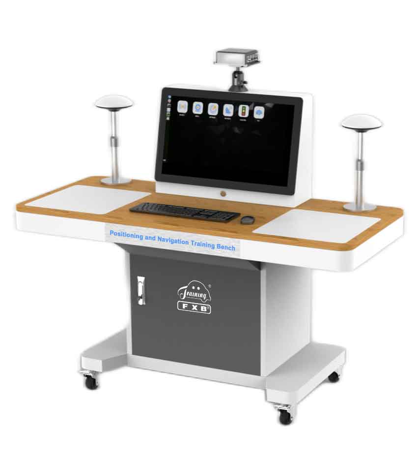
The positioning and navigation training bench is composed of GPS antenna, 4G communication antenna, GPS integrated navigation host, computing platform, GPS satellite model, human-computer interaction system, etc. It is equipped with double operation stations, which draw circuit diagrams and install signal detection terminals. It also equipped with a 27-inch touch monitor with wireless projection function, and a combined navigation host mounting bracket, which can realize stepless adjustment and simulate different orientations of the vehicle body. It can carry out practical training such as GPS integrated navigation assembly, debugging, calibration, testing, data analysis, algorithm verification and troubleshooting, and realize the teaching of functions such as the structural principle of GPS integrated navigation and the creation of GPS tracking maps. It is suitable for the teaching and research of GPS integrated navigation in related majors of intelligent networked vehicles.
ii. Features
1. Demonstrate the working principle of GPS integrated navigation.
2. Demonstrate the internal structure of GPS integrated navigation.
3. Restore the structural layout and function of GPS integrated navigation on intelligent networked vehicles.
4. Able to carry out the assembly operation of GPS integrated navigation.
5. Able to carry out the debugging operation the GPS integrated navigation.
6. Able to carry out the fusion calibration operation of GPS integrated navigation.
7. Able to perform GPS integrated navigation performance test, including GPS satellite signal test, Beidou satellite signal test, GLONASS satellite signal test, Galileo satellite signal test, etc.
8. Able to analyze the data of GPS integrated navigation.
9. Able to do algorithm verification of GPS integrated navigation.
10. Able to set GPS integrated navigation troubleshooting.
11. Able to realize RTK positioning test verification.
12. Able to realize the test verification of GPS satellite positioning function.
13. Able to realize the test verification of inertial navigation function.
14. Able to realize the test verification of GPS tracking function.
15. The human-computer interaction adopts a graphical interface, and the real vehicle model is used to visually display the installation position of the GPS integrated navigation on the intelligent networked vehicle, and the vehicle body attitude interface is displayed at the same time.
16. The human-machine interface has a calibration module. Through the calibration module, the network configuration of the GPS integrated navigation, the angle between the inertial navigation and the vehicle coordinate system, the value between the positioning antenna and the center lever arm of the rear wheel, the angle between the GNSS orientation baseline and the vehicle coordinate system, the inertial navigation and the vehicle coordinate system, guide to GNSS positioning antenna mast arm value and other configurations can be performed.
17. With intelligent fault setting and assessment function, it can set open circuit, short circuit, occasional, poor contact, reverse connection of CAN line and other faults to the main signal circuit.
18. Provide supporting teaching resources such as GPS combined navigation structure principle, assembly debugging and calibration test, including PPT, animation, operation video and task list.
iii. Basic Parameter
GPS integrated navigation technical parameters
IMU performance index: Gyro type MEMS
Gyro range ±400 º/s
Gyro bias stability 6°/h
Accelerometer range ±8g
Accelerometer bias stability 0.02mg
GPS positioning accuracy: RTK: 1cm+1ppm
DGPS: 0.4m
Single point L1/L2: 1.2m
Attitude accuracy 0.1° (baseline length ≥ 2m)
Communication interface: External interface 3×RS232 1×RJ45 1×CAN
1× Micro USB port
Wireless Communication: WIFI: 802.11b/g/n
4G: GSM/GPRS/EDGE 900/1800MHz
UMTS/HSPA+: 850/900/2100MHz
LTE: 800/1800/2600MHz
RTK system performance:
GPS interruption time 0S, position accuracy 0.02m, speed accuracy 0.02m/s
GPS interruption time 10S, position accuracy 0.50m, speed accuracy 0.06m/s
GPS interruption time 60S, position accuracy 5.80m, speed accuracy 0.30m/s
Display
Interface: HDMI USB3.0 USB2.0 VGA COM port*2
Refresh rate: 60HZ
Resolution: 1280×1024
RAM: 32GB
Display brightness: 250cd/m2
Backlight life: 5000h
Response time: 5ms
Touch Type: Multi-touch
Touch times: ≥35 million times
Network transmission method: wireless WIFI + Gigabit Ethernet port
Working temperature: -10℃-60℃
Computing Platform (NX)
CPU: Quad-Core ARM Cortex-A57 MPCore
Memory: 4gb 64-bit LPDDR4
GPU: New energy efficient opteron volta GPU
Storage: 16GBeMMC
Working power: DC12V 18W
Interface configuration: 1xGigabit Port, 1xHDMI 2.0 TYPE A
1xUSB 3.0 TYPE A 1xUSB 2.0 TYPE A
1×USB 2.0 Micro USB 1xRS232 1xTTL
3xDI 2xDO 1×l2C1xM.2 M Key 1xTF Slot
Product size: ≥1500*800*1200 (length*width*height)
Input voltage: AC220V
Working environment: working temperature -10℃~60℃
iv. Basic Configuration(Unit)
Indoor GPS signal transponder, 2 GPS antennas, 4G antenna, 4G IoT card, Combined inertial navigation host, Computing platform, 27-inch monitor, Beidou/GPS satellite model.