

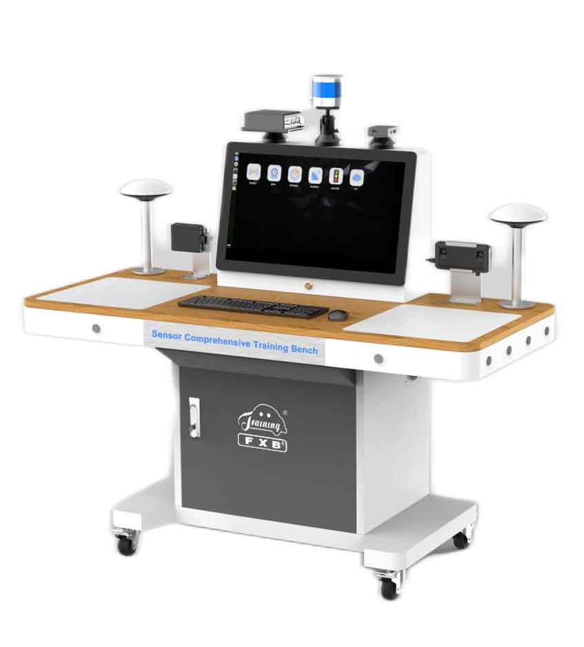
The sensor comprehensive training bench is composed of 16-line LIDAR, 77GHZ millimeter-wave radar, binocular camera, ultrasonic radar, GPS integrated navigation, automatic driving computing platform, etc. It is equipped with double operation stations, which draw circuit diagrams and install signal detection terminals. It also equipped with a 27-inch touch monitor with wireless projection function. It can carry out practical training such as LIDAR, millimeter-wave radar, binocular camera, ultrasonic radar, GPS integrated navigation, and automatic driving computing platform assembly, debugging, fusion calibration, testing, data analysis, algorithm verification and troubleshooting, etc. Realize the teaching of the structure principle of intelligent sensor, the creation of GPS tracking map and other functions. It is suitable for the teaching and research of sensors in related majors of intelligent networked vehicles.
ii. Features
1. Demonstrate the working principle of the environment perception sensor and computing platform of the autonomous driving system.
2. Restore the structural arrangement and function of the environment perception sensor and computing platform of the autonomous driving system on the intelligent networked vehicle.
3. Able to do assembly operation of the environment perception sensor and computing platform of the autonomous driving system.
4. Able to do debugging operation of the environment perception sensor and computing platform of the autonomous driving system.
5. Able to perform fusion calibration operation the environment perception sensor of the autonomous driving system.
6. Able to testing the performance of environmental perception sensors and computing platforms of autonomous driving systems.
7. Able to perform data analysis of environmental perception sensors and computing platforms of autonomous driving systems.
8. Able to perform algorithm verification of environmental perception sensors and computing platforms for autonomous driving systems.
9. Able to set up autonomous driving system environmental perception sensors and computing platform troubleshooting.
10. It can realize the integration of perception, decision-making and control test verification of autonomous driving system.
11. It can realize the simulation test of autonomous path planning.
12. Able to realize sensor information fusion technology and application.
13. The human-computer interaction adopts a graphical interface, and the real vehicle model is used to visually display the installation position of the environmental perception sensor of the autonomous driving system on the intelligent networked vehicle, and the fusion perception interface is displayed at the same time.
14. With intelligent fault setting and assessment function, it can set open circuit, short circuit, occasional, poor contact, reverse connection of CAN line and other faults to the main signal circuit.
15. Provide supporting teaching resources such as the structure principle, assembly debugging and calibration test of environmental perception sensor, including PPT, animation, operation video and task list.
iii. Basic Parameter
77GHZ millimeter wave radar
Detection distance: ±9°0.2m~250m@far range
±45°0.2m~70m/100m@near range/far range
±60°0.2m~20m@near rang
Detection distance resolution: 1.79m@far range
0.39m (0.2m at rest) @ near range
Working bandwidth: 76GHz-77GHz.
Distance detection accuracy: ≤ short distance ± 0.1m, long distance ± 0.4m.
Speed detection accuracy: ≤±0.1km/h.
Azimuth detection accuracy: ≤ short distance ±0.3°@0°, ±1°@±45°, ±5°@±60°, long distance ±0.1°.
Binocular camera
Baseline: 12CM
Lens focal length: 8mm
Dynamic range: 120DB
Resolution: 1280×720
Ranging range: 3m-100m
Image output format: YUV422
Field of view: horizontal 38°, vertical 21°
Adjustable pitch angle: 70°-90°
IMU: contains 3-axis gyroscope and 3-axis accelerometer
GPS integrated navigation technical parameters
IMU performance index: Gyro type MEMS
Gyro range ±400 º/s
Gyro bias stability 6°/h
Accelerometer range ±8g
Accelerometer bias stability 0.02mg
GPS positioning accuracy: RTK: 1cm+1ppm
DGPS: 0.4m
Single point L1/L2: 1.2m
Attitude accuracy 0.1° (baseline length ≥ 2m)
Communication interface: External interface 3×RS232 1×RJ45 1×CAN
1× Micro USB port
Wireless Communication: WIFI: 802.11b/g/n
4G: GSM/GPRS/EDGE 900/1800MHz
UMTS/HSPA+: 850/900/2100MHz
LTE: 800/1800/2600MHz
RTK system performance:
GPS interruption time 0S, position accuracy 0.02m, speed accuracy 0.02m/s
GPS interruption time 10S, position accuracy 0.50m, speed accuracy 0.06m/s
GPS interruption time 60S, position accuracy 5.80m, speed accuracy 0.30m/s
APA ultrasonic radar
Center frequency: 40±1.0kHz
Emission sound pressure: dB/30cm/10V sine wave≥120
Receiving sensitivity: dB/v/μbar≥-100
Beam angle (-6dB): 75±10 degrees
Aftershock time: less than 0.8ms
Static capacitance: 2000±15% (pf@120Hz25℃)
Input voltage: ≤140 Vp-p
Operating temperature: -40 to +80°C
Terminal type: XH.2P
UPA ultrasonic radar
Center frequency: 40±1.0kHz
Emission sound pressure: dB/30cm/10V sine wave≥100
Receiving sensitivity: dB/v/μbar≥-74
Beam Angle Horizontal: 120° Vertical: 60°
Aftershock time: less than 0.8ms
Static capacitance: 2000±10% (pf@120Hz25℃)
Input voltage: ≤140 Vp-p
Operating temperature: 40 to +80°C
Terminal type: XH.2P
Multi-Line Hybrid Solid-State LiDAR
Scanning channel: 16 channels
Ranging principle: Flight time method
Laser band: 905nm
Laser class: Class I (eye safety)
Detection distance: 70m
Measurement accuracy: ±3 cm
Measuring point rate: Single echo 320,000 points/second
Scanning frequency: 5Hz, 10Hz, 20Hz
Field of View: Horizontal 360° Vertical -15°~ 15°
Angular resolution: Horizontal 5Hz: 0.09º/ 10Hz: 0.18º/ 20Hz: 0.36°
Vertical 2°
Power supply range: 9V~36VDC
Power: 10W
Working temperature: -20℃ ~60℃
Communication interface: Ethernet, PPS
Shock: 500m/sec² for 11ms
Vibration: 5Hz-2000Hz, 3G rms
IP rating: IP67
Dimensions (D·H): Φ102 * 81mm
Weight: 1050g (standard)/650g (light)
Display
Interface: HDMI USB3.0 USB2.0 VGA COM port*2
Refresh rate: 60HZ
Resolution: 1280×1024
Display brightness: 250cd/m2
Backlight life: 5000h
Response time: 5ms
Touch Type: Multi-touch
Touch times: ≥35 million times
Network transmission method: wireless WIFI + Gigabit Ethernet port
Working temperature: -10℃-60℃
Size: 27 inches
Computing Platform (AGX)
Processor: Nvidia jetson AGX Xavier
CPU: 8-core ARM v8.2 64-bit CPL
Memory: 32gb 256-bit LPDDR44
GPU: New energy efficient opteron volta GPU
Storage: 32GBeMMc
DL Accelerator 2x NVDLA 10 TOPS (INT8)
Working power: DC12-50V 30W
Interface Type: Power LED x 1, USB 3.2 Gen 1 x 2,
USB 2.0 x 2, Micro-USB x 1,
GbE port x 2, PoE port x 8,
HDMI Port x 1, DisplayPort x 1,
Power Input x 1, MicroSD x 1,
Power & Reset Switch x 1,
Antenna port x 2,
RS-232 port x 2,
SATA ports x 2
Input voltage: AC220V
Working environment: working temperature -10℃~60℃
Equipment specifications: ≥1500*800*1200 (length*width*height)
iv. Basic Configuration(Unit)
16-line LIDAR, 77GHz millimeter-wave radar, Binocular camera, 12 ultrasonic radars, GPS integrated navigation, 27-inch display screen, Computing platform.